
Introduction
Every construction project that involves cutting, coring, or drilling into an existing structure carries one unavoidable risk: not knowing exactly what lies beneath the surface. A single miscalculated penetration can sever a live electrical cable, rupture a water line, or damage post-tensioned cables running through a concrete slab. These are not small mistakes — they can halt projects for days, cost lakhs in repairs, and in the worst cases, put workers' lives at risk.
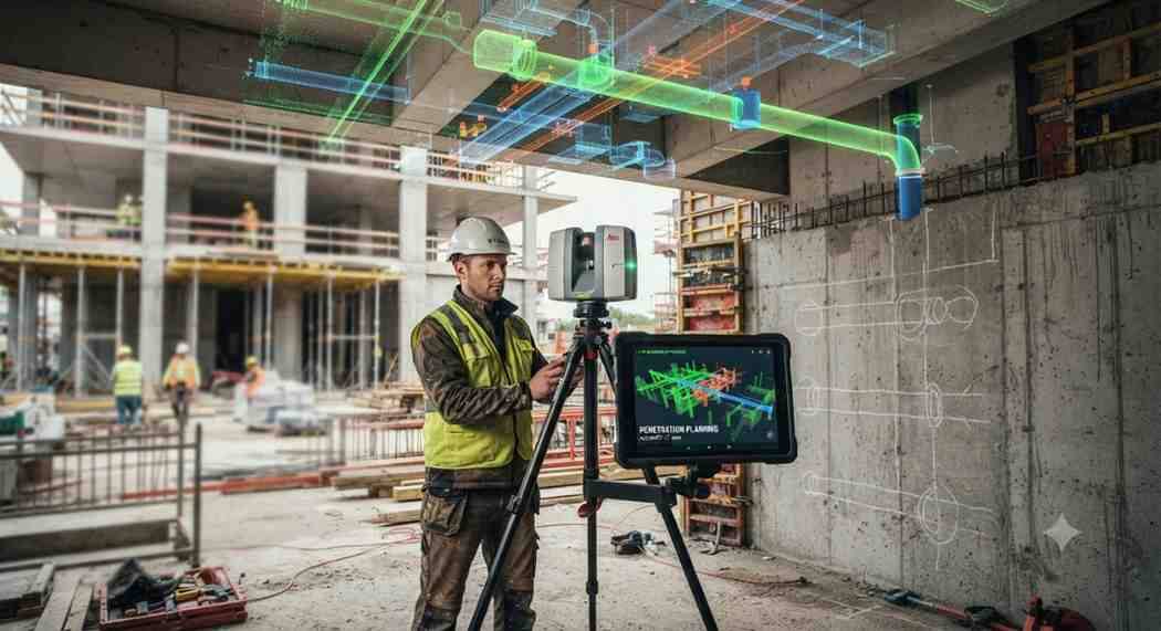
This is precisely why LiDAR scanning for construction penetration planning has become one of the most valuable tools in modern civil engineering and structural work. By capturing highly accurate, three-dimensional data of a site or structure before any cutting begins, LiDAR allows engineers, contractors, and cutting specialists to plan penetrations with a level of precision that was simply not possible a decade ago.
At Core Cutting India ([email protected]), we integrate advanced scanning technology into our core cutting, coring, and demolition workflows to ensure every penetration is planned safely, accurately, and efficiently. In this blog, we'll break down what LiDAR scanning is, how it supports penetration planning, and why it's becoming a non-negotiable step for serious construction projects.
What Is LiDAR Scanning?
LiDAR stands for Light Detection and Ranging. It is a remote sensing technology that uses laser pulses to measure distances with extreme accuracy. A LiDAR scanner emits thousands of laser points per second toward a surface or structure, and by measuring the time it takes for each pulse to bounce back, it generates a dense "point cloud" — a 3D digital map of the scanned area.
In construction, this point cloud becomes the backbone of planning. Instead of relying on old drawings, manual measurements, or guesswork, teams get an accurate digital twin of the actual as-built structure. This is critical because real-world buildings rarely match their original blueprints exactly — years of renovations, unauthorized modifications, and construction tolerances mean that what's on paper and what's on-site can differ significantly.
What Is Penetration Planning?
Penetration planning refers to the process of deciding exactly where, how deep, and at what angle a cut, core, or drill hole should be made into a concrete or masonry structure. This applies to:
- Core drilling for plumbing, HVAC, or electrical conduits
- Wall or slab cutting for new doorways, windows, or openings
- Anchor bolt installation
- Structural modifications and retrofitting
- Utility installation through existing floors and walls
Poor penetration planning is one of the leading causes of on-site accidents and costly rework in the construction and renovation industry. This is where LiDAR scanning steps in as a preventive, data-driven solution.
How LiDAR Scanning Supports Penetration Planning
1. Accurate 3D Mapping of the Structure
Before any cutting equipment touches the surface, a LiDAR scan produces a precise 3D representation of the wall, slab, ceiling, or column. This map shows exact dimensions, surface irregularities, existing openings, and structural elements. Engineers can then overlay proposed penetration points onto this model to check for conflicts before physical work begins.
2. Identifying Structural Elements and Obstructions
While LiDAR itself scans surfaces rather than sub-surface material (that's typically handled by Ground Penetrating Radar or GPR), it plays a crucial complementary role. LiDAR captures the exact geometry of a structure — beam locations, slab thickness variations, existing conduits, and visible reinforcements — which, when combined with GPR or X-ray scanning data, creates a complete picture of what's safe to cut and what must be avoided.
3. Clash Detection with BIM Models
Many modern construction and renovation projects use Building Information Modeling (BIM). LiDAR point clouds can be integrated directly into BIM software, allowing planners to run clash detection — automatically identifying where a planned penetration might intersect with a structural beam, existing service line, or reinforcement. This drastically reduces the chances of costly on-site surprises.
4. Precise Measurement for Core Cutting Depth and Angle
For core cutting and coring work specifically, knowing the exact slab thickness and angle of the surface is essential. LiDAR scanning provides millimeter-level accuracy, allowing our teams at Core Cutting India to calculate the exact depth required for a clean, controlled cut — minimizing vibration, dust, and structural stress on surrounding areas.
5. Documentation and As-Built Verification
Once penetrations are complete, a follow-up LiDAR scan can document the as-built condition. This creates a verified digital record that can be referenced for future renovations, maintenance, or compliance audits — something particularly valuable for commercial and industrial facilities.
LiDAR vs. GPR: Which One Do You Need?
A common question we receive is whether LiDAR scanning can replace Ground Penetrating Radar (GPR) for concrete scanning. The honest answer is: they serve different purposes, and the best penetration planning uses both.
- LiDAR scanning captures the visible geometry of a structure — surface shape, dimensions, existing openings, and spatial relationships between elements.
- GPR (Ground Penetrating Radar) and other non-destructive testing methods look inside the concrete to detect rebar, post-tension cables, conduits, and voids.
When combined, LiDAR gives you the "where" in three-dimensional space, and GPR gives you the "what's inside" at that exact location. Together, they form a complete penetration planning package that dramatically reduces risk.
Why LiDAR Scanning Matters for Indian Construction Projects
India's construction landscape includes a mix of modern high-rises, decades-old commercial buildings, industrial plants, and heritage structures — often with incomplete or outdated drawings. This makes accurate scanning technology even more valuable locally.
- Retrofitting and renovation projects in older buildings often lack reliable structural drawings, making LiDAR scanning essential for safe planning.
- Industrial facilities with dense underground and overhead utility networks benefit from precise 3D mapping before any core cutting or slab opening work.
- High-rise residential and commercial towers require careful penetration planning to avoid disturbing post-tensioned slabs, a common structural system in Indian high-rises.
- Infrastructure projects such as metro stations, flyovers, and public buildings demand documented, verifiable planning processes for compliance and safety audits.
At Core Cutting India, our teams regularly work across these environments, applying scanning-informed planning to deliver safer, faster, and more accurate cutting and coring services.
The Core Cutting India Approach to Scanning-Based Penetration Planning
Our process typically follows these steps:
- Site Assessment — Understanding the scope of work, structure type, and specific penetration requirements.
- Scanning Phase — Deploying LiDAR and, where necessary, GPR scanning to capture both surface geometry and internal composition.
- Data Analysis — Reviewing point cloud data and scan results to identify safe penetration zones and flag any conflicts.
- Planning and Marking — Translating scan data into precise, marked locations on-site for cutting or coring.
- Execution — Carrying out core cutting, coring, or demolition work with equipment calibrated to the planned depth, angle, and diameter.
- Post-Work Verification — Optional follow-up scanning to document the final as-built condition.
This structured, technology-driven approach minimizes downtime, protects existing infrastructure, and ensures compliance with safety standards.
Benefits of LiDAR-Informed Penetration Planning
- Reduced Risk of Damage: Avoid cutting into live utilities, structural reinforcement, or post-tension cables.
- Faster Project Timelines: Eliminate delays caused by unexpected obstructions discovered mid-cut.
- Cost Savings: Prevent expensive repairs, rework, and potential legal liability from accidental damage.
- Improved Worker Safety: Give on-site teams confidence that penetration points have been verified before cutting begins.
- Better Documentation: Maintain accurate digital records for compliance, maintenance, and future renovation planning.
- Higher Precision: Achieve cleaner cuts with less waste material and reduced structural stress.
Common Applications
- Core drilling for HVAC ducts and plumbing risers
- Cutting openings for elevators, staircases, or structural modifications
- Installing anchors and fasteners in load-bearing walls
- Utility trenching and slab penetrations in industrial plants
- Renovation of heritage or older commercial buildings with unclear structural records
- Data center and server room installations requiring precise floor penetrations
Choosing the Right Partner for LiDAR Scanning and Penetration Planning
Not every cutting or coring contractor has access to advanced scanning technology or the expertise to interpret the data correctly. When selecting a partner for construction penetration planning, look for:
- Experience with both LiDAR and GPR scanning technologies
- A track record of working on complex or older structures
- The ability to integrate scan data with BIM or CAD models
- Transparent reporting and documentation practices
- A safety-first approach to every project, regardless of size
Conclusion
Construction penetration planning is no longer something that should rely on assumptions or outdated drawings. With LiDAR scanning, contractors and engineers gain access to precise, three-dimensional data that transforms how core cutting, coring, and structural modification projects are planned and executed. When combined with complementary technologies like GPR, LiDAR scanning becomes a powerful safeguard against costly mistakes, project delays, and safety hazards.
At Core Cutting India, we bring this technology-driven approach to every project we undertake — helping clients cut, core, and modify structures with confidence, precision, and safety at the forefront.
For expert LiDAR scanning and penetration planning services, reach out to Core Cutting India at [email protected].
People Also Ask
1. What is LiDAR scanning used for in construction? LiDAR scanning is used to create precise 3D maps of buildings and structures. In construction, it supports as-built documentation, clash detection, renovation planning, and — critically — penetration planning for core cutting, coring, and drilling work.
2. How does LiDAR scanning help in penetration planning? LiDAR captures the exact geometry, dimensions, and surface conditions of a structure. This data helps engineers identify the safest and most accurate locations for cutting or drilling, reducing the risk of hitting structural elements or utilities.
3. Is LiDAR scanning better than GPR for concrete scanning? LiDAR and GPR serve different purposes. LiDAR maps surface geometry and spatial layout, while GPR detects what's inside the concrete, such as rebar and conduits. For complete penetration planning, both are typically used together.
4. How much does LiDAR scanning cost for construction projects? Costs vary depending on project size, structure complexity, and scanning scope. Contact Core Cutting India at [email protected] for a project-specific quote.
5. Can LiDAR detect rebar inside concrete slabs? No, LiDAR does not see through solid materials — it scans surface geometry only. Detecting rebar or embedded reinforcement inside concrete requires Ground Penetrating Radar (GPR) or similar non-destructive testing methods, which are often used alongside LiDAR for complete planning.